Zambia, which is located in the south of the African continent, is divided into 10 administrative provinces. Although each province has limited powers, it has regional administrations.
In 2011, some districts in the Northern and Eastern provinces were united to form the Muchinga region, thus increasing the number of provinces in the country to 10.
The provinces, which were formed by taking administrative and cultural conditions into consideration, were also divided into 105 districts in total by taking administrative and cultural conditions into account.
The number of districts throughout the country, which was 72 until 2013, was increased to 105 districts with new districts.
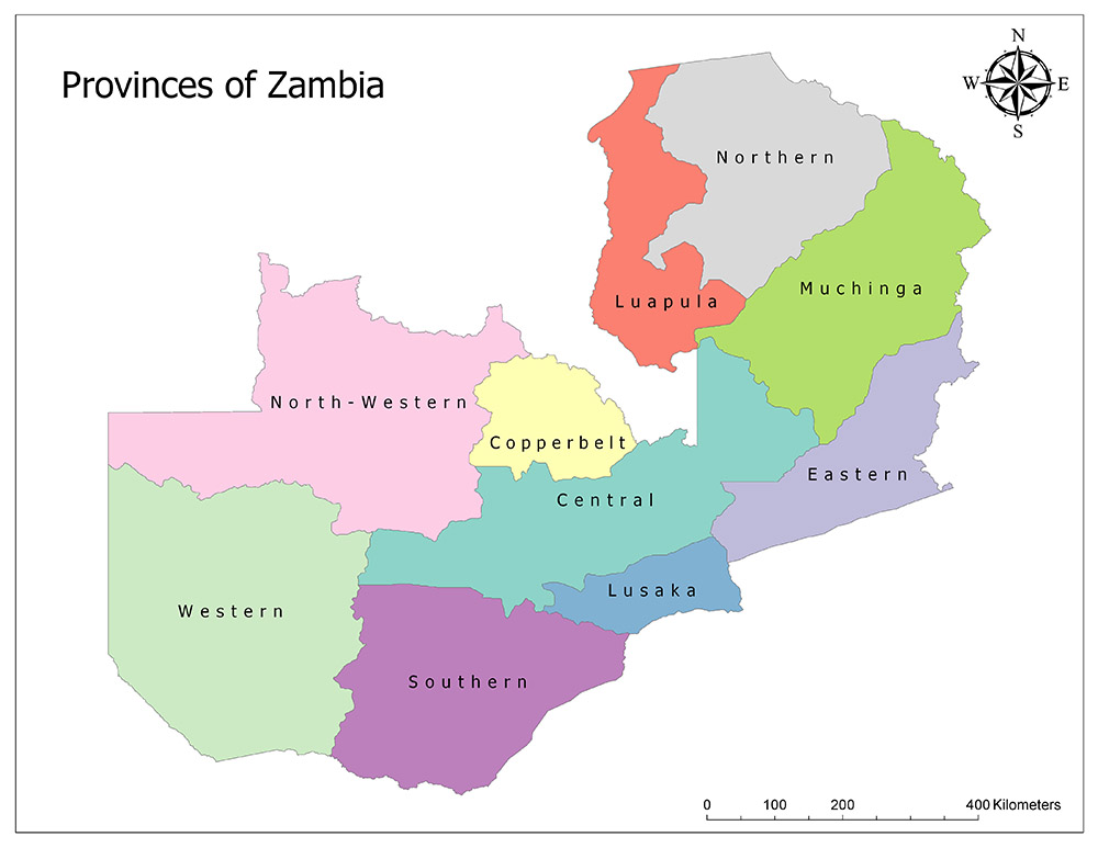
Ten Provinces of Zambia
Zambia is divided into ten provinces as the highest administrative structure. These provinces are Central, Copperbelt, Eastern, Luapula, Lusaka, Muchinga, North-Western, Northern, Southern and Western.
Central
Central Province is one of Zambia’s 10 existing provinces. The Central Province is the third-largest region of the country in terms of surface area, while it is one of the medium-density regions of the country in terms of population.
The province is located in the center and neighboring with all other provinces of the country. It is also adjacent to the Democratic Republic of Congo in the north. Its administrative capital is Kabwe.
According to 2018 official data, 1,743,999 people live throughout the Province. It is the third largest province in the country with an area of 110,450 square kilometers.
Copperbelt
Copperbelt is one of Zambia’s total 10 provinces. Copperbelt Province is one of the smallest regions of the country in terms of surface area, while it is the second largest region in terms of population.
It is adjacent to the Northwest Province in the West, the Central Province in the South and the Democratic Republic of Congo in the North and East. Its administrative capital is Ndola.
According to 2018 official data, 2,542,132 people live in the province. With a surface area of 31,328 square kilometers, it is the second smallest province in the country.
Eastern
The Eastern Province is one of the 10 provinces in total in Zambia. Eastern province is one of the middle-sized regions of the country in terms of surface area, while it is the third largest country in terms of population.
Muchinga Province in the north, Lusaka Province in the southwest and Central Province, Malawi in the east and Mozambique in the south. Muchinga Province was created in 2011 and districts from the Eastern province were added. Its administrative capital is Chipata.
According to 2018 official data, 1,961,269 people live in the province. With a surface area of 51,476 square kilometers, it is the fourth smallest region in the country.
Luapula
Luapula is one of the 10 provinces of Zambia. Luapula province is one of the smallest regions of the country both in terms of area and population. The region is adjacent to the Democratic Republic of Congo in the west and the Northern Province in the east. Its administrative capital is Mansa.
According to 2010 official data, 991,927 people live in the region. It is one of the small provinces of the country with an area of 50,567 square kilometers.
Lusaka
Lusaka is one of Zambia’s 10 existing provinces. Lusaka Province is the smallest region of the country in terms of area, while it is the largest region in terms of population. It is adjacent to Central Province in the north, East Province in the northeast, South Province in the southeast, Mozambique in the east and Zimbabwe in the south. Its administrative capital is Lusaka, which is also the capital of the country.
According to 2018 official data, 3,186,336 people live in the province. Lusaka, which makes up 20% of the population of Zambia with this population, is the smallest region of the country with an area of 21,896 square kilometers.
Muchinga
Muchinga Province is one of the 10 provinces of Zambia. Muchinga was founded in 2011 by bringing together some of the districts belonging to the North and East regions. It has borders with East in the south, Central in the southwest, Luapula in the west, Northern regions in the northwest, Tanzania in the north and Malawi in the east. Its central city is Chinsali.
According to 2015 official data, 895,058 people live in the region. With an area of 87,806 square kilometers, it is one of the mid-sized provinces of the country.
North-Western
North-Western is one of the ten provinces of the African country, Zambia. The northwestern region is one of the largest provinces in terms of surface area and the smallest in terms of population. It is adjacent to Western Province in the southwest, Central Province in the southeast, Copperbelt Province in the east, Democratic Republic of Congo in the north and Angola in the west. Its administrative capital is Solwezi.
According to 2015 official data, 833,818 people live in the province. With a surface area of 125,826 square kilometers, it is the second largest province in the country.
Northern
Northern Province is one of the ten provinces of the African country of Zambia. While the northern province is the largest province in terms of area, it became a medium-sized region with the establishment of Muchinga Province with a portion of this province in 2011.
For the same reasons, it became the third-largest province of the country in terms of population and became one of the middle-density provinces.
It is adjacent to Luapula Province in the west, Muchinga Province in the southeast, Tanzania in the northeast and Democratic Republic of Congo in the north. Its administrative capital is Kasama.
According to 2015 official data, 1,304,435 people live in the province. With a surface area of 77,650 square kilometers, it is one of the mid-sized provinces of the country.
Southern
The Southern Province is one of the ten provinces of the African country of Zambia. The southern province is the fifth largest province in terms of area, while the fourth largest province in terms of population. It is adjacent to Central Province in the north, Lusaka Province in the northeast, West Province in the west, Zimbabwe in the east and south, and Namibia in the southwest. Its administrative capital is Livingstone.
According to 2010 official data, 1,853,464 people live in the province. With a surface area of 85,283 square kilometers, it is one of the mid-sized provinces of the country.
Western
The Western province is one of the ten provinces of Zambia. The western province is the largest province in terms of area, while it is the third smallest province in terms of population.
It is adjacent to Northwest Province in the North, Central Province and South Province in the east, Angola in the west and Namibia in the south.
Its administrative capital is Mongu. According to 2015 official data, 991,500 people live in the province. It is the biggest province of the country with an area of 126,386 square kilometers.